
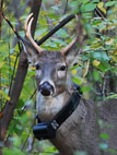
The map was aimed to show locations of Anna-Lisa, three other tracked animals have 'store-on-board' gps units. Unfortunately "new" version of the Google-spreadsheets we were forced by the mighty company are not capable of making dynamic kml files. Besides, the Google-Earth plugin which you see below will stop working in December 2015. We work on the solution to stop dependecny on the Google/Alphabet.
Last refreshed
Near real-time data
How this map is pulling the data? Step by step instructions are here:
,E.Potapov, V. Hronusov 2012. Extreme dynamic mapping: Animals map themselves on the 'Cloud'.
,In: "Whitmeyer, S.J., Bailey, J.E., De Paor, D.G., and Ornduff, T., eds., Google Earth and Virtual Visualizations in Geoscience Education and Research: Geological Society of America Special Paper 492": 139-145. doi:10.1130/2012.2492(10).
Canadian Broadcast Corporation was so impressed with the method of relaying the coordinates via Google's Cloud, so it decided to interview the coder.
Check the project web page for details.
Current weather recorded by the Bryn Athyn College weather station
Radar loop
Image below is the view of the night skies from the latest fix of the deer.
Back to Eugene Potapov home page
You would need a Google-Earth plugin to see the dynamic map.
How dark it is during the night?

Back to Bryn Athyn College
